The old State of Gwalior in India’s madhyadesa
Standing amidst the forest clad ridges, low topped hills and plateaus, valleys, plains, and many rivers (Chambal and its tributaries), the old State of Gwalior in Central India has been a silent witness to many historical proceedings from times immemorial.

Geographically the territory could be divided into two parts: the northern part that included the city of Gwalior and its fort, and Malwa plateau section with Ujjain as the main city. From being under the Scindia maharajahs during the colonial era, post independence the once mighty State of Gwalior is now limited to being a city and is part of Madhya Pradesh. The old State of Gwalior has yielded rich archaeological finds, and the region goes back in history to more than 2000 years. Various excavated remains from ancient sites such as Ujjain (Avantika), Dasapura (Mandsaur), Vidisha (Besnagar), Kotwal, among many others, have given interesting insights into the ancient Indian history of this region. Vidisha finds frequent mentions in ancient Buddhist, Hindu, and Jain texts, and was once the capital of the Sunga dynasty under king Agnimitra (2nd c. BCE), who has been commemorated by Kalidas in his play Malvikagnimitra. Ujjayini or Ujjain is another important ancient site, and is also frequently mentioned in various Jain, Buddhist, and Hindu texts. It was once an important centre for trade and learning, and flourished under the Mauryas, and later the Guptas. Besides these, Kantipuri (Kotwal village) and Padmavati (Pawaya) were two cities in the Gwalior territory under the Naga dynasty in the 3rd c. CE, and finds mention in the Puranas; while Tumbavana (Tumain village) was an important ancient Buddhist city and finds mention on a Sanchi railing and a Gupta era inscription.
Historical examination of the Gwalior fort
From the Gwalior State territorial borders when we narrow down our search to the northern parts and on the Gwalior city, we find that history of this place goes well back, past the 5th c. CE. when the Guptas ruled. The hill on which the fort stands was variously known as Gopachala/Gopagiri/Gopadri, as mentioned in some of the ancient Sanskrit inscriptions, meaning the shepherd’s hill, and is a 300 feet high rocky outcrop that is long and narrow, and gives a bird’s eye view of the surroundings.


In the 6th c. CE we find two Huns named Toramana and Mihirakula (father – son duo) taking over the area after defeating the imperial Guptas, and establishing their capital at Sialkot. The fort walls still hold a Sanskrit inscription in the name of Mihirakula (discovered by Cunnigham in 1861) that tells us of the building of a Surya temple. Few years later in 528 CE, Yasodharman along with few other kings managed to defeat Mihirakula, who then migrated to Kashmir and established his Hun rule there; thereafter memories of his cruelties remained fresh in the minds of many generations of Kashmiris.


Once the fort was won back from the Huns and brought under the rule of Yashodharman in 528 CE, there ensued chaos and the picture remains hazy for another 8 decades, until Emperor Harsha of Kanuaj took control of the area in the early 7th c. CE. After Harsha’s death in 648 CE, the region again went back into anarchy. The next ruler of importance, whose inscription (876 CE) is seen in the Chaturbhuja temple inside the fort premises, is Raja Mihira Bhoja Deva. His dynasty is likely to have held power until the Kachhwahas came into prominence in the 10th century CE and took over the fort and adjoining areas around it. It is locally believed that the current fort’s foundations were laid at this time under the Kachhwaha king Suraj Sen, who was cured of leprosy after drinking water from a spring near the Suraj Kund under ministrations of a sage named Gwalipa. The Kacchawahas ruled until 1129 CE, and even managed to buy off Mahmud Ghazni in 1021 CE, thus sparing the fort from his devastating attacks. In 1129 CE the Pratiharas (another Rajput dynasty) usurped the throne from a rather weak and decadent Kacchwaha ruler, only to lose it to Qutbddin Aibak who took the fort in 1196 CE. The Pratiharas won back the fort 14 years later, and it remained under their rule until 1232 CE when Iltutmish captured the fort after eleven months long siege, killing 700 prisoners right before his tent and destroying many of the temple structures inside the fort. This was also the first time when Jauhar occurred inside the Gwalior fort premises. The fort remained with the Delhi sultanate until 1398 CE, when the Tomars (another Rajput dynasty) took control over it. The Tomars ushered in the golden era of the Gwalior fort and gave the region a certain degree of economic prosperity and stability. It was during the Tomars’ rule that many of the beautiful Jain sculptures were carved inside the fort premises, likely at the behest of some Jain merchant prince.
The most famous ruler of the Tomar dynasty was Raja Man Singh who built the beautiful Man Singh palace also known as Man mandir, and the Gujari mahal for his queen Mrigyanayani, the later being famous for starting the Gwalior School of Music that produced some of the best musicians of the era, including Tansen. After the death of Raja Man Singh in 1517 CE, the fort was taken over by Ibrahim Lodi, and from him it went to Babar, who left behind his mark by ordering the destruction of the Jain murtis; however his orders were only partly carried out owing to the massive size of the murtis. Thereafter, the fort remained with the Mughals, with a short break of 15 years when Sher Shah Suri overthrew Humayun. Akbar turned this fort into a political prison and for the next two centuries the fort walls witnessed many terrible deaths of Mughal princes and other state prisoners. Deaths mostly occurred by the constant dosing of posto or poppy seeds, and the prisoners died a slow and painful death as the poison broke down their minds and bodies. Victims of this kind of death included the two sons of Dara, and Aurangzeb’s own son Sultan Muhammad.
After Aurangzeb’s death, the fort went under the control of the Gohad chiefs, and later to the Marathas under Mahadaji Scindia. In 1780, the East India Company captured the fort after a brave nighttime attack under Captains Popham and Bruce, but the then governor Warren Hastings placed the fort under the Gohads again. Within four years the Marathas recaptured the fort, finally losing it to the Company during the Second Anglo-Maratha War. Between 1808 and 1844 the fort control oscillated between the Scindias and the Company, when finally in 1844, the fort was finally given to the Maratha Scindias, albeit under Company authoritarianism. During the 1857 mutiny while some of the soldiers stationed in the fort rebelled against the Company, the ruler Jayaji Scindia remained faithful to the British government. In 1886 complete ruling rights to the fort was transferred to the Scindia family by the British Crown in exchange for Jhansi. The Scindias kept their control over Gwalior until 1947.

Monuments inside the Gwalior fort
The main monuments inside the fort premises are Teli Ka- Mandir, Sas Bahu temple,

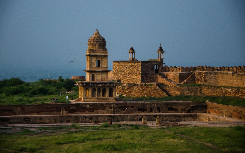
Man Mandir, Badal Mahal, Chaturbhuj temple, Rock-cut Jain tirthankaras, Ganesha gate, Urwai gate, alamgiri gate, the kunds including the jauhar kund, etc. The Manmandir palace built by Raja Mansingh (1486-1516 CE), a well known patron of music and architecture, is considered as the most remarkable example of an early Hindu palace architecture. The extensive eastern facade of the palace which is 300 feet long has six beautiful circular towers with domed cupolas. The palace wall is famous for its inlaid tiles in enamelled yellow, green. and blue colours, that show figures of various animals like ducks, tigers, crocodiles, and elephants, along with different other motifs. The palace interior has two open courtyards that have rooms all around with beautiful ceilings and balustrades in different designs. There are also rooms in the palace basement that were initially used as pleasure chambers, which were converted into prison cells later in the Mughal period
The Man Mandir palace and other buildings around it


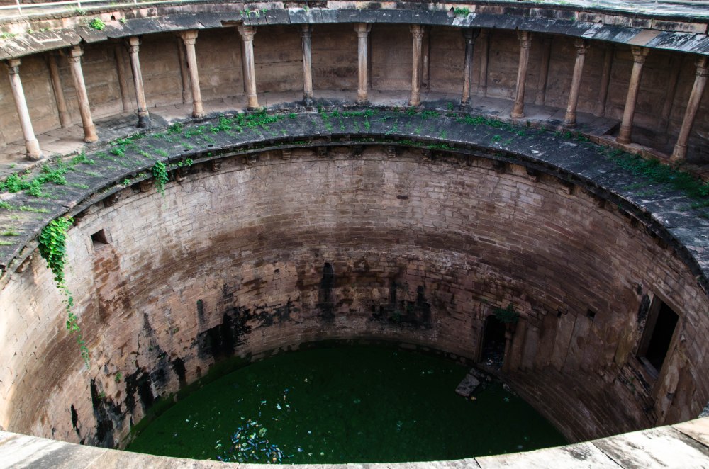
The entrance to a beautiful circular baoli is through this pillared hall. Locals say this was earlier a Shiva temple, and Jahangir had taken the lingam and thrown it down over the fort wall. Later it was discovered by a farmer tilling his land, and now there is a temple where the lingam was unearthed.
slideshow: different palace buildings and structures near the Man Mandir palace
Teli ka Mandir
The ‘oilman’s temple’ as it is often referred to in the colonial era books and records, is the most imposing structure within the fort premises, standing tall at more than 100 feet

height. Recently from some inscriptions on the temple walls it has been derived through palaeontology that the temple was built in the mid 8th c. CE, which coincides with Yasovarman of Kanauj who was then ruling this part. Earlier historians had varied largely over the date of construction of this temple, with dates ranging from 7th to 11th century CE, and Krishna Deva suggesting that the temple could have been constructed under Mihira Bhoja in the 9th c. CE. There are also contrasting views on the original presiding deity, and it could have been Vishnu, Shiva, or the Shaivite saptamatrikas (as derived from the long rectangular shape of the sanctum that were built to hold long panels of the matrikas or the anantasayana Vishnu). Presently the sanctum of this trikuta, pancharatha styled temple holds a Shiva lingam and a nandi. Externally the temple can be divided into two distinct parts: the lower part with its many niches having tall pinnacles, and the upper half that contains horizontal mouldings, some plain and some carved.

Teli ka mandir as it stands today

Michael Meister in his research paper “Geometry and measure in Indian temple plans: rectangular temples” presents an interesting concept where he says that the architect of Teli ka mandir had taken a square sanctum of 4X4 and increased it by half, and after taking into context various other dimensional and thickness ratios seen in the temple, it can be derived that “simple ratios governing the plan and created by the grid might be compared to harmonic ratios… few structures better embody harmonious proportions than the eighth century Teli ka mandir.”


Saas bahu temple
The saas bahu temple are a pair of temples, one large and one small, situated on the eastern end of the fort rock, near Suraj kund . The temple pair is also known as

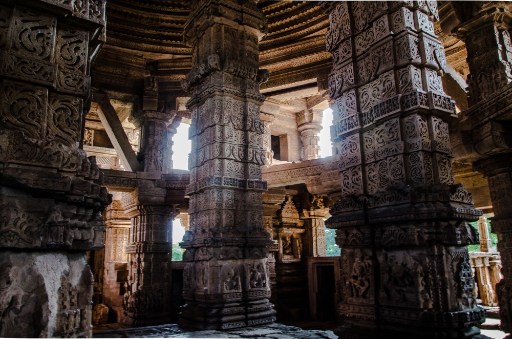
sahastrabahu or the thousand armed (infinite), referring to Vishnu. From a Sanskrit inscription found on the mandapa of the larger temple it is known that temple construction was started by Padmapala, a Rajput prince from the royal family of the Kacchawahas, during the reign of his brother and king Mahipala in 1093 CE. The doorways, ceilings, and the massive pillars in the larger temple (saas) are exquisitely carved, though all figures carved on pillars and temple walls have been vandalised during the Delhi sultanate rule, and some are now beyond recognition. The saas temple, which was dedicated to Vishnu, has been reconstructed and repaired to some extent, but the sanctum and shikhara were completely ruined. The smaller temple (bahu), a dedication to Shiva, remains just as a shell of the mandapa in its former glory, and the sanctum is non-existent.


Left: The entrance way to the mandapa has the garuda on the lintel and the Hindu trinity carved on the panel above it. The base of the door jambs show the river goddesses with their attendants.
Right: exquisitely carved ceiling of the porch (saas temple)


Remaining sculptures on the outside wall of the saas temple


Monolithic rock cut Jain tirthankaras
There are rock cut images of the Jain tirthankaras on both sides of the slope of the Urwahi road, and some of them are colossal in size. It is their sheer sizes that saved them from being destroyed by Babar’s army, despite his orders to break them. Some of the images are seen standing and some seated, while all are sheltered in rock cut niches or small caves. The rock cut Jain sculptures were mostly made during the rule of the Tomars in 15th century CE, and are unique because of their sizes as well as their numbers. The largest murti is that of a standing tirthankara half along the Urwahi road, which is 57 feet tall.


The Gwalior fort has many other monuments to visit, the most important among them being the Gujari mahal. The mahal comes when one enters through the eastern side and

crosses the Gwalior Gate and the Hindola gate. This beautiful palace was built by Raja Man Singh in the 15th c. CE for his favourite queen Mriganayani, who belonged to the Gujari caste group. It is now a museum and houses priceless artefacts, therefore a must visit for all that visit the fort. There is another museum housed in a building near the Man Mandir palace, which also holds priceless artefacts, unfortunately photography was not allowed inside when we had visited. There is a gurudwara within the fort premises named Gurdwara Data Bandi Chorh Sahib, which is associated with the imprisonment and subsequent release of Guru Har Gobind Sahib from his confinement within the Gwalior Fort prison (17th century).
When to go: Gwalior is best explored during the cooler winter months, or during the monsoons when the place turns a beautiful green. The summers can get pretty harsh here, so best avoidable. The fort will take one whole day to explore, and there are many other monuments to see in the Gwalior city besides the fort, and even outside the city in nearby places, so 2-3 days stay is advisable.

Some of the books that I studied in order to understand and write on the Gwalior fort history and details of the structures inside:
- ASI reports by Alexander Cunningham (1862-65), Volume II, Shimla, 1871.
- A Handbook of Gwalior by M. B. Garde, Gwalior, 1936.
- Geometry and Measure in Indian Temple Plans: Rectangular Temples by Michael Meister, Artibus Asiae, Vol. 44, No. 4, 1983, pp. 266-296.
- Gwalior Today by Michael Brown, ASI, 1940.


Very beautifully written with nice pictures and information . But I would admit that it is avoidable place to visit in summer .
LikeLike
It is totally avoidable in summers..extremely hot and one cannot explore or even enjoy the place.
LikeLike